


FlyQ Pocket
Опис програми FlyQ Pocket
FlyQ Pocket from Seattle Avionics is the absolutely free, powerful aviation app that every pilot needs. It’s brilliantly easy to use and astonishingly fast. It takes full advantage of the Internet when available but also stores information on the device for offline use.
FlyQ Pocket combines aviation weather, airport info, FBO info, fuel prices, and flight planning capability to put tremendous power just a click or two away. You can plan a flight with an auto-router that wind-optimizes your flight to get you there as fast as possible. Victor Airways, GPS Direct routing, Jet Airways, or None. FlyQ Pocket is ready for it all.
FlyQ Pocket shares flight plans, pilot profiles, and aircraft profiles with FlyQ EFB for iPad and FlyQ Online for Web.
Using FlyQ Pocket is simple because all major functions are always just a tap away.
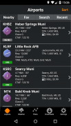
Airport Information
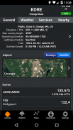
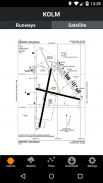
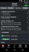
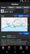
Start FlyQ Pocket and within seconds it finds the nearest airports and displays succinct weather, fuel, and operational details about them—without even tapping a button. Or use the Search feature to find airports by ident or name. Even browse by state/city to select airports without typing. Want more info about an airport? Tap and all the details you need (but no excess clutter) appears instantly. On the first airport page, you immediately see operational information, fuel prices, runways, navaids, the FAA airport diagram (if applicable) and an embedded satellite map image of the airport. Want to call the local ATIS? Tap the phone number and your SmartPhone quickly connects you. Tap the weather tab and see the current temperature and sky conditions, a Nexrad radar image of the area, the nearest METARs and TAFs, winds-aloft, and even an official Lockheed Martin or DUATS weather briefing. Best of all for those of us who aren’t 21 anymore, one tap zooms the METARs, TAFs and weather graphics to full screen, large font versions that anyone can read—even in turbulence. Another tap gives you an easy-to-read 7 day forecast. Quickly find the FBO details you need—fuel information, telephone numbers, rental cars, nearby attractions and more. The Favorites feature gives quick access to commonly-used airports.
Weather Information
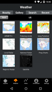
Tap the Weather tab and FlyQ Pocket instantly locks on to your GPS position and displays temperature, Nexrad images and local METARs and TAFs. Or choose from a large gallery of US and Canadian weather graphics, many of which are animated. Quickly check the weather anywhere on the globe by entering an airport identifier, city name, even a zip code. Of course, FlyQ Pocket keeps track of your recent selections for quick future access and stores graphics and METARs/TAFs on the phone so they’re available even when you’re not connected to the Internet (such as in flight).
Flight Planning
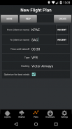
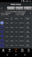
No time to plan a flight? Give us 30 seconds and watch FlyQ Pocket assemble the perfect wind-optimized flight plan. Tell FlyQ Pocket where to depart, where to land, and how to fly there (Victor airways, Jet Airways or GPS Direct) and FlyQ Pocket plots the whole course including all the navaids and intersection—not a simple straight line. It even uses the winds-aloft forecast to give you the ideal altitude for each leg of your trip. To make your life easier, FlyQ Pocket automatically requests an official Lockheed Martin or DUATS weather briefing so you’re good to go. And since filing the flight plan takes one tap and about 3 seconds, it’s easy and quick to fly safely. FlyQ Pocket remembers your recent flights and home airport so you can often plan a flight by picking from a list of recently used airports rather than typing.
Moving Map and Approach Plates
FlyQ Pocket does not include a moving map or approach plates. It’s designed for pre-flight planning rather than in-flight use. FlyQ EFB for iPad is the big brother to FlyQ Pocket with step up features like a Moving Map. See FlyQ Online for a Web-based flight planning solution.
FlyQ Pocket from Seattle Avionics is the absolutely free, powerful aviation app that every pilot needs. It’s brilliantly easy to use and astonishingly fast. It takes full advantage of the Internet when available but also stores information on the device for offline use.
FlyQ Pocket combines aviation weather, airport info, FBO info, fuel prices, and flight planning capability to put tremendous power just a click or two away. You can plan a flight with an auto-router that wind-optimizes your flight to get you there as fast as possible. Victor Airways, GPS Direct routing, Jet Airways, or None. FlyQ Pocket is ready for it all.
FlyQ Pocket shares flight plans, pilot profiles, and aircraft profiles with FlyQ EFB for iPad and FlyQ Online for Web.
Using FlyQ Pocket is simple because all major functions are always just a tap away.
Airport Information
Start FlyQ Pocket and within seconds it finds the nearest airports and displays succinct weather, fuel, and operational details about them—without even tapping a button. Or use the Search feature to find airports by ident or name. Even browse by state/city to select airports without typing. Want more info about an airport? Tap and all the details you need (but no excess clutter) appears instantly. On the first airport page, you immediately see operational information, fuel prices, runways, navaids, the FAA airport diagram (if applicable) and an embedded satellite map image of the airport. Want to call the local ATIS? Tap the phone number and your SmartPhone quickly connects you. Tap the weather tab and see the current temperature and sky conditions, a Nexrad radar image of the area, the nearest METARs and TAFs, winds-aloft, and even an official Lockheed Martin or DUATS weather briefing. Best of all for those of us who aren’t 21 anymore, one tap zooms the METARs, TAFs and weather graphics to full screen, large font versions that anyone can read—even in turbulence. Another tap gives you an easy-to-read 7 day forecast. Quickly find the FBO details you need—fuel information, telephone numbers, rental cars, nearby attractions and more. The Favorites feature gives quick access to commonly-used airports.
Weather Information
Tap the Weather tab and FlyQ Pocket instantly locks on to your GPS position and displays temperature, Nexrad images and local METARs and TAFs. Or choose from a large gallery of US and Canadian weather graphics, many of which are animated. Quickly check the weather anywhere on the globe by entering an airport identifier, city name, even a zip code. Of course, FlyQ Pocket keeps track of your recent selections for quick future access and stores graphics and METARs/TAFs on the phone so they’re available even when you’re not connected to the Internet (such as in flight).
Flight Planning
No time to plan a flight? Give us 30 seconds and watch FlyQ Pocket assemble the perfect wind-optimized flight plan. Tell FlyQ Pocket where to depart, where to land, and how to fly there (Victor airways, Jet Airways or GPS Direct) and FlyQ Pocket plots the whole course including all the navaids and intersection—not a simple straight line. It even uses the winds-aloft forecast to give you the ideal altitude for each leg of your trip. To make your life easier, FlyQ Pocket automatically requests an official Lockheed Martin or DUATS weather briefing so you’re good to go. And since filing the flight plan takes one tap and about 3 seconds, it’s easy and quick to fly safely. FlyQ Pocket remembers your recent flights and home airport so you can often plan a flight by picking from a list of recently used airports rather than typing.
Moving Map and Approach Plates
FlyQ Pocket does not include a moving map or approach plates. It’s designed for pre-flight planning rather than in-flight use. FlyQ EFB for iPad is the big brother to FlyQ Pocket with step up features like a Moving Map. See FlyQ Online for a Web-based flight planning solution.
FlyQ Pocket - інформація про APK
Версія APK: 2.2ID пакета: org.seattleavionics.flyqОстання версія FlyQ Pocket


Додатки в цій категорії

Вам також може сподобатися...


